

Côte-des-Neiges is a beautiful neighbourhood. Politically, it is combined with neighbouring Notre-Dame-De-Grâce, as one combined borough within the City of Montreal. But, this walk we are highlighting reflects the true Côte-des-Neiges that we know – the intersections of Queen Mary and Côte-des-Neiges on the south, Barclay and Côte-des-Neiges on the north, Victoria and Van Horne on the west and Wilderton and Van Horne on the east. This is where this walk takes us. As many of you know, WalkMontreal is a combined initiative of a He and a She, and the He grew up in Côte-des-Neiges in the 1970’s and 1980’s, so this is a personal stomping ground evoking memories of youth. Côte-des-Neiges has a very large and diverse immigrant population, mainly South Asian, Filipino, Arab, Vietnamese, African, West Indian, Russian, Jewish, Chinese, Iranian and Latin American. Neither the French nor English languages dominate here. The population is about 100,000 residents. There is also a large student population, particularly from the Université de Montréal. And there is a big health care presence here as well.
This walk will take you thru the streets, see original shopping malls from the 1950’s and 1960’s, see its hospitals, some Art Deco, the diverse dwellings and we have even included a memory of Bob Dylan from 1962. The walk is on flat terrain, with some downhill and then some uphill terrain. It is not a difficult walk, but, it is just over 9 kilometres in total (almost 6 miles) – continuous walking is about 2 hours, but, we were stopping for photos and a quick break, so we stretched it out to 4 hours.
We did this walk on Sunday August 16th, 2020 between 9am and 1pm. From start to finish the temperature was between 23C to 27C (84F to 89F), with lots of sun and blue skies. Below is the google map we made so that you can follow along.
We started the walk at the corner of Côte-des-Neiges and Queen Mary roads.

Queen Mary Road looking west at corner of Côte-des-Neiges. On the left you can see the impressive St. Joseph’s Oratory.

At the north-west corner of this intersection is the original Musée Historique Canadienne (now closed).
– beautiful Art Deco exterior built in 1935.

Looking north on Côte-des-Neiges Road.

Looking north on Côte-des-Neiges Road.

The 165 Côte-des-Neiges bus.

Outdoor market.

Entrance to the Côte-des-Neiges Metro station.

École Notre-Dame-des-Neiges (aka Academie St. Joseph) – built 1916-1918.

Notre-Dame des Neiges Church – built 1939.

Notre-Dame des Neiges Church Presbytery.

Since the Covid-19 pandemic is still on, the city has printed and posted these safety guidelines. It is multi-lingual to reflect the neighbourhood.

Continue north on Côte-des-Neiges Road.


St. Kevin Church – built 1952-1953.

You will now cross the intersection with Côte-Sainte-Catherine Road.


Continue north, as you go downhill.

The Jewish General Hospital – built in 1931-1932, the original building is an Art Deco design.

As you pass the hospital, you will see how big it has evolved.

A Covid-19 testing station. The yellow religious building in the back was the Mother House of the Soeurs de St. Croix – built in 1894.

You will now cross the intersection with Van Horne Avenue.

The western edge of Martin Luther King Park.

At 3600 Kent Avenue (corner of Côte-des-Neiges) is an old farmhouse built in 1815.

If you turn around and look south from where you walked.

Original Bell Building – built 1936-1937.

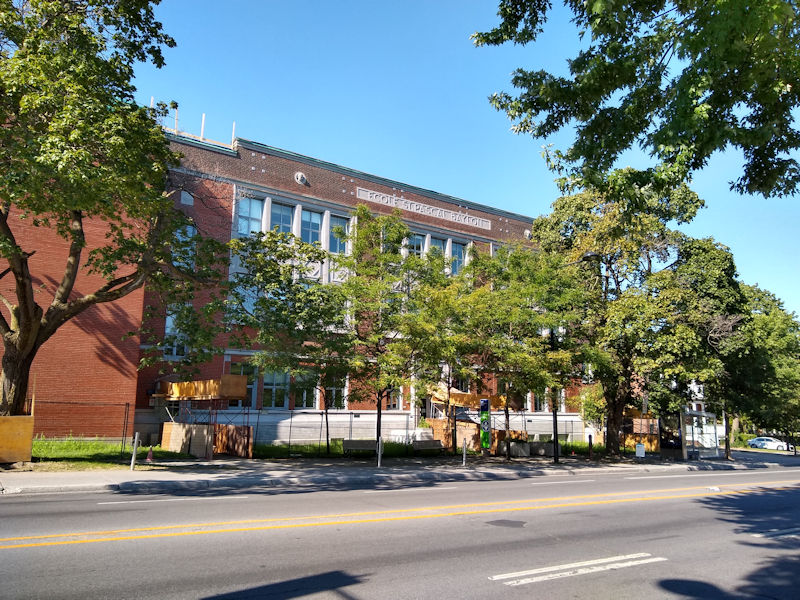
École Saint-Pascal-Baylon – built 1933.
Continue on Côte-des-Neiges Road.

Saint-Pascal-Baylon Church – built 1917.

You will now be at the intersection with Barclay Avenue.

In 1968, the Plaza Côte-des-Neiges was just completed and opened to the public.
It included a modern office building, with an indoor mall that stretched all along the west side of Côte-des-Neiges Road for 3 blocks.
It boasted of having 2 levels, 68 stores and parking for 1,000 cars.

A newspaper ad described the Grand Opening as “Turned on Shopping is Here!” with the image of a flower girl. This was 1968.

The mall itself doesn’t look very big, but, it covers that whole side of the street, with 1 level on the street and 1 level below the street.

A 24 foot bronze sculpture was created by Hans Schleeh back in 1968. Titled “Trialogue”, it symbolized the excitement of shopping.
The below image shows each figure holding a square frame representing boxes and standing on large concrete blocks.

“Trialogue” is still here today! The boxes are gone, they are each missing a leg, and the large concrete blocks have disappeared as well.


When you are at the intersection of Barclay Avenue, walk south on Barclay. This street is entirely of small apartment buildings built in 1950.

When you get to the intersection of Victoria Avenue, turn left and walk south on Victoria.

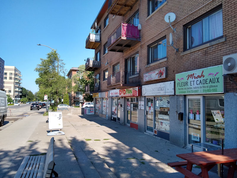
Victoria Avenue is covered in small businesses and shops.


You will now reach the intersection with Van Horne Avenue.

The 161 Van Horne bus, Plamondon Metro at the corner and the Van Horne Shopping Centre in the rear.

The Van Horne Shopping Centre, built in 1955, it is an outdoor strip mall in the centre of a vibrant and bustling neighbourhood.

Aerial view of the Van Horne Shopping Centre – (with credit to First Capital).

Van Horne Shopping Centre.

The Brown Derby restaurant was an original anchor to the Van Horne Shopping Centre, opening in 1955 with the mall.
It was modeled on the New York style of delicatessen and was a favourite for locals and those who moved away would always return to eat there. It closed in 2000.
Below are some ads showing whats on the menu.


Corner of Victoria and Van Horne avenues.

Bourret Street, side street off Victoria.

Victoria Avenue.

Continue south on Victoria.

A beautiful public garden along Victoria.

A beautiful public garden along Victoria.

You will now come to the intersection with Côte-Sainte-Catherine Road.

Côte-Sainte-Catherine metro is at the south-east corner.

So on July 2nd, 1962 a young 21 year old Bob Dylan was in Montreal and played at a folk music coffee house called “The Finjan”.
We found an ad from 1962 for The Finjan in Montreal and it clearly shows the address as 5650 Victoria.
The Finjan was owned by Shimon Ash and legend has it that there were 12 or 15 people in the club listening to Bob Dylan sing.
If you go to Bob Dylan’s official website, you will see the set list he played that day: http://www.bobdylan.com/date/1962-07-02-finjan-club/
You can do a search on the internet for this recording from 1962 – it exists.
If anyone has any memories of the Finjan, or Shimon Ash, or was even there that July day 58 years ago, we would love to hear from you.


This is 5650 Victoria Avenue – (the building was built in 1949).

The address of 5650 is the door in the centre, so the Finjan must have been up stairs (which are apartments today).

Walking north on Côte-Sainte-Catherine Road you will see the back of the Jewish General Hospital.

Apartment buildings on Côte-Sainte-Catherine Road.


Passing the side of the Jewish General Hospital.

You will be crossing back across the intersection with Côte-des-Neiges Road.
Art Deco.

Côte-des-Neiges Presbyterian Church – built in 1879-1880.

You will now cross the intersection with Decelles Avenue.

Corner of Côte-Sainte-Catherine and Decelles.

Residence Maria Goretti – built 1953.


Collège Jean-de-Brébeuf – built 1927-1928.

The Centre hospitalier universitaire Sainte-Justine – built 1957.

You will reach the intersection with Darlington Avenue. Turn left and head north on Darlington.

Apartment buildings on Darlington Avenue.


Darlington Avenue.

This is the original Logan Elementary School – built in 1953. It is now école Félix Leclerc.

This is the work site building Logan School in 1953 – credit to BANQ (Bibliothèque et Archives nationales du Québec).

Continue to walk to Van Horne and then turn right and walk east 2 blocks to the intersection of Wilderton Avenue and Van Horne.

Here you will find the original Wilderton Shopping Centre – built in 1959. It is currently undergoing an impressive change.

Aerial view of the Wilderton Shopping Centre – dated June 2012 – (with credit to First Capital).

Turn around and head back west on Van Horne Avenue, walking by the new build for the Wilderton.

Steinbergs supermarket was an anchor when the Wilderton opened in 1960.
Below is an ad for Steinbergs and the price of groceries some 60 years ago.
Sliced bread was 19 cents. Sardines were 29 cents, ….the Ice Cream !

Continue on Van Horne and at the corner of Darlington you will see a massive public garden for the community.

Looking back across the public garden, you can see the current development on the Wilderton.

Corner of Van Horne and Linton avenues.

Passing Mahatma Gandhi Park.

Turn right on Hudson Road and you will see the Rehabilitation Institute Gingras-Lindsay de Montreal – Lindsay Hall.
This was the original Montreal Convalescent Hospital – built in 1933.

At the first corner you will see Kent Park and Kent Avenue. Walk thru Kent Park.
Below is the Swimming Pool.

The park has a basketball court.

And also a professional track and field , as well as soccer.

Kent Park.

As you walk west thru Kent Park, it becomes Martin Luther King Park.

With baseball diamonds.

Below is an aerial view of Kent Park from 1969 – credit to Archives de Montréal.
Only the pool, a rudimentary track and soccer field with a baseball diamond are evident.
East is at the top, the Wilderton Shopping Centre is top middle, and the Montreal Convalescent Hospital nestled between the trees.

Below is an aerial view of Kent Park from 1969 – credit to Archives de Montréal.
This image looks west. It must have been hot that day, as the swimming pool looks packed.

Go to the intersection of Kent and Decelles avenues on the north side of the park and head south on Decelles.

Decelles Avenue, crossing Linton Avenue.

Linton Avenue, looking east.

Continue walking up Decelles until you get to Côte-Sainte-Catherine, turn left and walk east 1 block to Gatineau Avenue.

Apartment buildings on Gatineau.


You will now arrive at the original Côte-des-Neiges village.

Fire Station No 27 – built in 1909-1910.

Montreal Fire Dept in 1940’s- credit to BANQ (Bibliothèque et Archives nationales du Québec).


Gatineau Avenue, corner of Lacombe Avenue.

If you walk back west to Decelles, you will see the original Fendall House – built in 1906.

Continue on down to Lacombe Avenue and walk west.

You will see St. Mary’s Hospital – built 1934.

The back of St. Mary’s Hospital on Jean Brillant Street.

Walk back to Côte-des-Neiges Road, to Queen Mary and then walk east.

An original concrete public water fountain !

Walk thru Place du 6-Décembre-1989, and reflect on those taken from us far too soon.

Across the street on Decelles is La maison Jarry-Dit-Henrichon – built in 1713-1751.

Walk one street over to the north to Jean Brillant Street and head east to McKenna Street.
You will see the The Université de Montréal in the distance.
This is a massive university and much of the land in this area is owned and occupied by it.


Beautiful old homes on McKenna.


And on Lacombe street as well.


If you walk east on Lacombe Avenue, you will come to the sprawling ground of the U de M. Walk up the hill to the main building.
Below is the Pavilion Roger Gaudry, a beautiful Art Deco structure built between 1924 to 1943 and designed by Ernest Cormier.


Everything of the building is impressive.

We hope you enjoyed the walk as much as we did.
For those who have never visited these streets, please come and make your own walks in this neighbourhood.
And for those who know these streets from the past, we hope to have stirred up fond memories.
We leave you with these three images below, courtesy of BANQ (Bibliothèque et Archives nationales du Québec).
Can you spot the landmarks?
Aerial view of Côte-des-Neiges circa 1950.

Aerial view of Côte-des-Neiges circa 1955.

Aerial view of Côte-des-Neiges circa 1957.

Back to Top
website and images © www.walkmontreal.com
Beautiful photos thank you
Thank you Albert, glad you enjoyed them!
My old neighborhood! used to live on Van Horne and Decelles thanks!
Awesome! Thanks for Sharing Anissa. hope you enjoyed the photos
Hi,
very intersting!
I live in one of the 50ies “small appartment buildings” in avenue Lacombe. Unfortunately, the house has undergone some modifications and I’m trying to figure out how it looked like before.
Is there a source of older pictures of this type of buildings?
cheers
Martin
Hello Martin, thanks for dropping by WalkMontreal! Many older photos or info we research we find on BANQ or Archives de Montreal web sites. We don’t know of any specific web site that deals with old buildings in Montreal.
Very nice, nostalgic virtual walk. Disappointed you did not mention Van Horne School, at the corner of Van Horne and Victoria. I attended that school for a few years. It was a regular elementary school then; now the building is apparently home to several EMSB schools. My family lived on La Peltrie, near Westbury. We moved there in 1951 or 2, just when construction finished. The sidewalks and road were built about 6 months after we moved; before that the street was mud. The street was distinctive because all the houses were identical. That’s not so obvious now that many of them have been renovated.
Hello Norman, apologies on omitting Van Horne School. Someone else also mentioned this. Well, we occasionally edit our walks and add in missing information. Lets see what we can do and pay respect to this respected school. Thank you for visiting WalkMontreal.
C&D.
Hi,
Very nice memories. We used to live on Van Horn across from the rehab center in the early 60’s then to Bouchette corner Victoria.
Walked both Wilderton and Van Horn shopping centres.
Nothing looks the same now.
Regards, GK
Hi Gabe; Thank you for visiting WalkMontreal. Yes, we recall a Woolworths in the Wilderton way back in 1970s. The shopping centre has basically been cut in half and condos built. Still a beautiful area and lots of parks.