
 (above image of Côte-Saint-Antoine Road, showing Arlington Lane – March 2, 2024) © WalkMontreal
“Côte-Saint-Antoine Road” is the fifth in a series of micro-walks in Montréal. We are planning on extending our micro-walks throughout the island of Montreal, not just confining them to the downtown core. This way, wherever you may be, there will be one close to you. They are designed so that you can get out and stretch your legs, see some interesting sites and appreciate the history these streets have to offer.
“Côte-Saint-Antoine Road” walk starts at Place Guy-Viau (where the 3 corners of Côte-Saint-Antoine, Sherbrooke and Hampton meet) and will take us along Côte-Saint-Antoine Road from NDG thru Westmount and end at Vimy Park (where the 3 corners of Côte-Saint-Antoine, Sherbrooke and Clarke meet).
This walk is fabulous both for it’s scenery, architecture and history, and we will attempt to highlight and pay tribute to Indigenous (The St. Lawrence Iroquoians) history, early farmers of New France, and the emergence of modern Notre-Dame-de-Grâce and Westmount and their architecture – all on this one road. Long before the arrival of Europeans, there were Indians in this area who made their trails here which included Côte-Saint-Antoine Road and Arlington Lane. Their fresh water source were springs along the part of the mountain where King George Park is and they may have had a settlement where Vimy Park (Garden Point) is today. Even an Indian burial ground was discovered not far from this area in the late 1800’s. The Sulpician religious order arrived in the 17th century and soon land was given to French farmers who settled along Côte-Saint-Antoine Road. Names such as Des Carries (Décary, Décarie), Prud’homme, Leduc, Hurtubise and St. Germaine are prominent in the area. This area was excellent for fruit orchards. A few old farmhouses exist amongst the newer NDG and Westmount homes and their splendid architecture. We will walk and search for all of this!
C & D did this walk on Saturday March 2, 2024. Temperature was 4C (39F) and it was cloudy with intermittent light rain. The walk itself is not long, a total of 3 KM (1.9 miles), but can be hilly. The terrain slowly inclines as you get to Girouard Avenue and then reaches it’s height at Lansdowne Avenue and then begins to decline. Please follow along the below map.
Start of walk !

This is the intersection of three streets: Sherbrooke Street West, Hampton Avenue and Côte-Saint-Antoine Road.

This little park is Place Guy-Viau named after Guy Viau, the Quebec artist, teacher and director of museums and galleries.

Place Guy-Viau.

Let’s start walking and head east on Côte-Saint-Antoine Road.

You can see many apartment buildings right around this area where we start the walk in NDG.

Alley off Côte-Saint-Antoine Road.

Alley off Côte-Saint-Antoine Road.

Walking east along Côte-Saint-Antoine Road, passing Wilson Street.

Approaching the original Saint Augustine of Canterbury School built in 1924, 5619 Côte Saint Antoine Road.

Alley off Côte-Saint-Antoine Road.

The original Saint Augustine of Canterbury School built in 1924, 5619 Côte Saint Antoine Road.


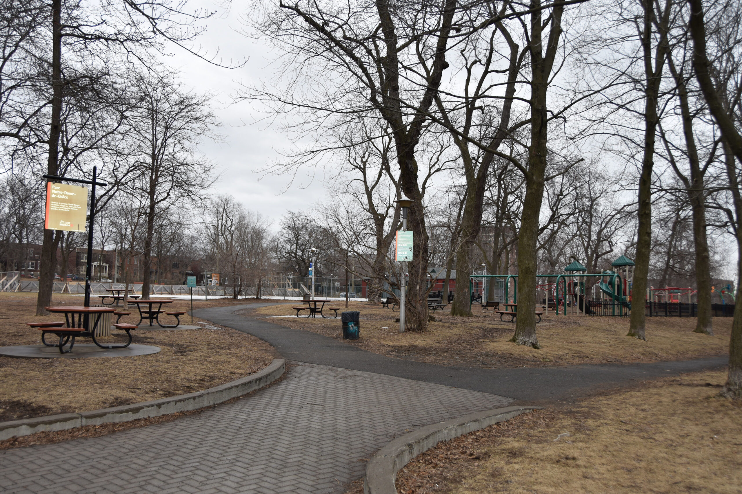
Parc Notre-Dame-de-Grâce.


Parc Notre-Dame-de-Grâce. Marcil Avenue borders it on the west.

Parc Notre-Dame-de-Grâce.
Original Saint Augustine Church built in 1919, 5565 Côte-Saint-Antoine Road.

Original Saint Augustine Church built in 1919, 5565 Côte-Saint-Antoine Road.

Continue walking east on Côte-Saint-Antoine Road.

Intersection of Girouard Avenue and Côte-Saint-Antoine Road. Here comes the 63 Girouard bus!

Looking south on Girouard Avenue.

5456 Côte-Saint-Antoine Road at intersection of Addington Street.

We will now cross the Décarie Expressway.

Crossing the Décarie Expressway below us.

Looking south while crossing the Décarie Expressway.

Once you cross over the Décarie Expressway, you will see the Notre-Dame-de-Grâce Library built in 1912, corner of Botrel Street and Côte Saint Antoine Road with Fire Station No.34 on the side.

Côte-Saint-Antoine Road at Avenue Prud’homme.

NDG Community Centre, built in 1932, at 5311 Côte-Saint-Antoine Road.


Intersection of Décarie Boulevard and Côte-Saint-Antoine Road.

Looking south on Décarie Boulevard.

5225 Côte-Saint-Antoine Road built between 1912 and 1913, for Marie-Louise-Aimée Chaput, the widow of Berthélémi-Télésphore Décarie. This is at intersection of Northcliffe Avenue.

5225 Côte-Saint-Antoine Road built between 1912 and 1913, for Marie-Louise-Aimée Chaput, the widow of Berthélémi-Télésphore Décarie. This is at intersection of Northcliffe Avenue.

Coming to intersection of Côte-Saint-Antoine Road and Avenue de Vendôme.

Looking north up Avenue de Vendôme. So a piece of pop culture trivia, the 1931 Canada Census and the 1934-35 Lovell’s Directory have Leonard Cohen’s family living at 4028 Vendôme. Leonard was born in 1934.

Maison Décarie, built between 1731-1742, at 5138 Côte-Saint-Antoine Road at corner of Vendôme. This home is on the first concession granted by the Sulpicians to French settlers.

Maison Décarie, built between 1731-1742, at 5138 Côte-Saint-Antoine Road at corner of Vendôme. This home is on the first concession granted by the Sulpicians to French settlers.

Walking by Maison Décarie.

Continue walking east on Côte-Saint-Antoine Road.

Intersection of Grey Avenue.

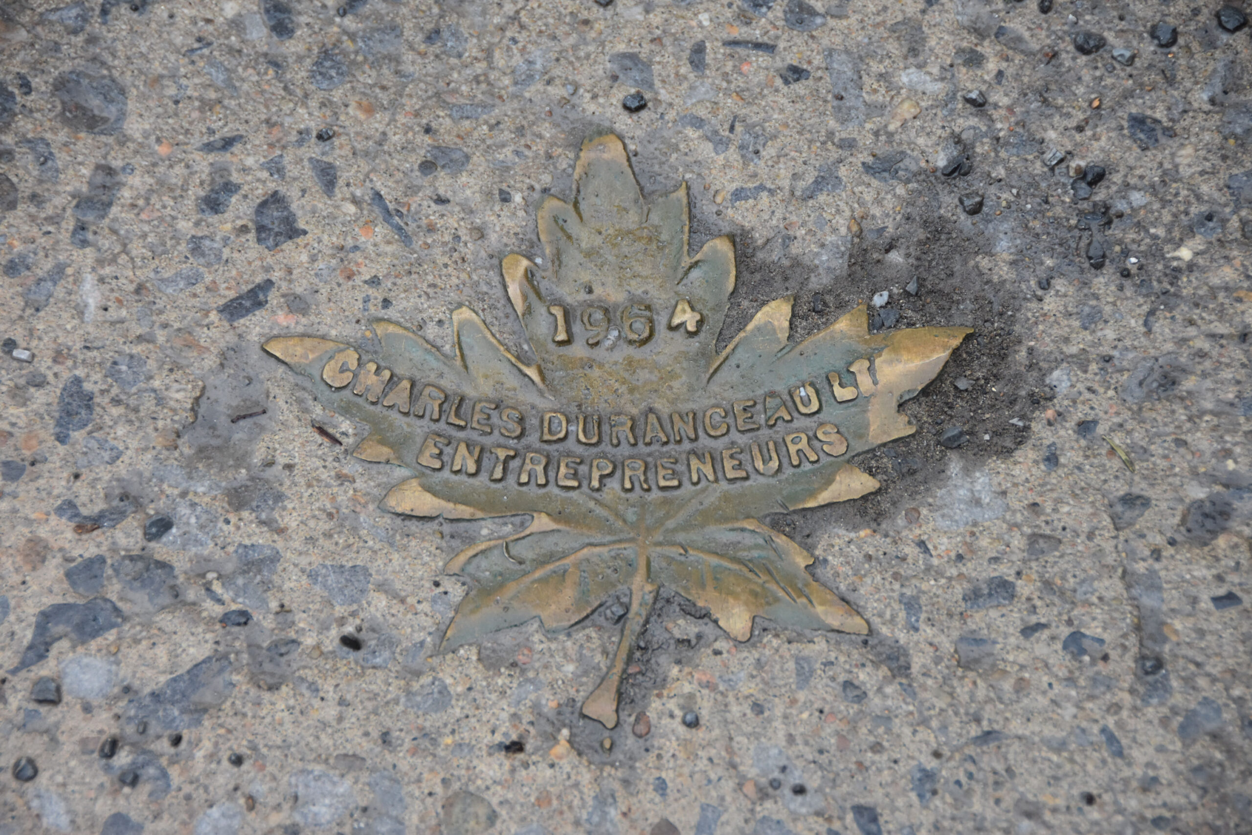
The sidewalk we are walking on.
The sidewalk we are walking on, built in 1964.
Côte-Saint-Antoine Road between Grey and Claremont, this is where we leave Montreal and enter Westmount.

Intersection of Claremont Avenue. We are now in Westmount.

Looking south on Claremont Avenue.


Maison Isabella Nicol, built between 1869-1875, at 649 Côte-Saint-Antoine Road.

Maison Isabella Nicol, built between 1869-1875, at 649 Côte-Saint-Antoine Road.

Maison Isabella Nicol, built between 1869-1875, at 649 Côte-Saint-Antoine Road.

Maison Isabella Nicol, built between 1869-1875, at 649 Côte-Saint-Antoine Road.

At the next intersection of Prince Albert Avenue, look south to capture a beautiful view. So when you look south on the mountain slopes, you can see how the environment was suited for growing. The sun, rising in the east, covers this whole mountain side in sunlight before it moves off and sets in the west.

So we know that there were farmers here with their farms. But what exactly were they growing? The below newspaper clipping gives us insight into the size of a particular farm, the house, what was on it and what they grew. This clipping is from The Gazette (Montreal) in 1833. The lot for sale on Côte-Saint-Antoine Road was 50 acres. The house was situated on the “brow of the Mountain, built of stone“. There was an “assortment of 250 fruit trees…consisting of Apples, Pears, Plumbs, Peaches, and also the best kinds of Grapes, Gooseberries, Currants, Raspberries and Strawberries.” The fruit and berries grown here must have been delicious!

Looking south down Prince Albert Avenue.

Continue on and at 561 Côte-Saint-Antoine Road is Maison Hurtubise, the oldest house in Westmount. Built in 1739, on land purchased in 1699 by Jean Hurtubise. Due to being so far away from the safety of Ville Marie, the inhabitants of Ville Marie called it “La haute folie”.

561 Côte-Saint-Antoine Road is Maison Hurtubise, the oldest house in Westmount. Built in 1739, on land purchased in 1699 by Jean Hurtubise. Due to being so far away from the safety of Ville Marie, the inhabitants of Ville Marie called it “La haute folie”.

Maison Hurtubise – photo from 1897 (credit: McCord Stewart Museum).

Intersection of Victoria Avenue and Côte-Saint-Antoine Road.

At 515-513 Côte-Saint-Antoine Road is Maison Justine-Solomé Hurtubise, built in 1847. The house is named “Riverview”.

At 515-513 Côte-Saint-Antoine Road is Maison Justine-Solomé Hurtubise, built in 1847. The house is named “Riverview”.

At 515-513 Côte-Saint-Antoine Road is Maison Justine-Solomé Hurtubise, built in 1847. The house is named “Riverview”.

At 515-513 Côte-Saint-Antoine Road is Maison Justine-Solomé Hurtubise, built in 1847. The house is named “Riverview”.

Continue walking on Côte-Saint-Antoine Road, coming up to Grosvenor Avenue.

Looking south on Grosvenor Avenue.

Continue walking on Côte-Saint-Antoine Road, coming up to Roslyn Avenue.

Looking south on Roslyn Avenue.

Continue east on Côte-Saint-Antoine Road, we are approaching Lansdowne Avenue. At this intersection is the highest elevation for Côte-Saint-Antoine Road.


Intersection at Côte-Saint-Antoine Road. Lansdowne Avenue and Belmont Crescent.

It was right here that the St.Germain farmhouse stood. Photo from 1897. (credit: James Cranston Shaw Bennett / McCord Stewart Museum).

The small road in the centre is Belmont Crescent, which will take you to Belmont Avenue and King George Park.

Looking south on Lansdowne Avenue.

Looking south on Lansdowne Avenue.

Looking south on Lansdowne Avenue.

This photo is looking up Lansdown Avenue in 1910. (credit: McCord Stewart Museum).

If we take a deviation and walk up Belmont Crescent, there is this small island of vegetation.

When standing on this little island, if you look south you will see Arlington Lane stretched out before you. Arlington Lane was an Iroquois trail.

This is the small island on the left, Belmont Crescent on right and intersection of Côte-Saint-Antoine and Lansdowne in the rear.

Zooming in on Arlington Lane (Iroquois Trail). You can see how it descends and heads straight south.

Walk up Belmont Crescent and on your left is Belmont Avenue.

Pop culture trivia. The second house on the right is 599 Belmont Avenue. This was the home where Leonard Cohen grew up in as a child, teenager and young man.

We won’t walk up Belmont Avenue, we want to keep going straight to the side entrance of King George Park.

King George Park (also known as Murray Hill or Murray Park).

We are not going to explore the park, we are going to just walk through it to the bottom heading straight back to Côte-Saint-Antoine Road.

So around the area of King George Park were the mountain springs where the Iroquois would have a source of fresh water.

King George Park. You can see how steep it is with the city of Montreal in the distance.

King George Park in 1935. (credit: Harry Sutcliffe).

King George Park.

King George Park.

Make your way down the park onto Côte-Saint-Antoine Road.

Intersection of Côte-Saint-Antoine Road and Strathcona Avenue.

Walking east on Côte-Saint-Antoine Road. The back of homes on east side of King George Park that are on Murray Avenue.

Continue walking, Mt.Stephen Avenue is on your left.

Intersection of Côte-Saint-Antoine Road and Murray Avenue. There are accounts of the mountain springs up the area of today’s Murray Avenue as well.

Walking east on Côte-Saint-Antoine Road.

We come to two splendid homes on land referred to as Metcalfe Terrace. This stone house under renovation is the Goode House, built in 1840, at 178 Côte-Saint-Antoine Road.

This home is the second of the pair of the Metcalfe Terrace homes and was built in 1840 at 168 Côte-Saint-Antoine Road.

This home is the second of the pair of the Metcalfe Terrace homes and was built in 1840 at 168 Côte-Saint-Antoine Road.

We now come to the intersection of Forden Avenue and Côte-Saint-Antoine Road.
The last of the Indian springs was said to be on the western side of Forden Avenue and in 1879 it was filled in; (“A View of Their Own. The story of Westmount”; by Aline Gubbay – published by Price-Patterson 1998).
There is a stone road marker here that is from 1684, with the newer stone wall built around it.

The stone marker can be seen protected inside the current stone wall. This marker is from 1684 and believed to mark the distance from the Sulpician Fort de la Montagne on Sherbrooke Street to this spot.

This marker is from 1684 and believed to mark the distance from the Sulpician Fort de la Montagne on Sherbrooke Street to this spot. It is protected here, please do not tamper with it.

Continue walking on Côte-Saint-Antoine Road and you will come to the Congregation Shaar Hashomayim synagogue, built in 1921-1922.

Intersection of Metcalfe Avenue and Côte-Saint-Antoine Road.

At the intersection of Church Hill Avenue and Côte-Saint-Antoine Road.


St. Matthias Anglican Church, built in 1910-1912.

Intersection of Kensington Avenue and Côte-Saint-Antoine Road. We pass by the back of the Westmount Lawn Bowling Club.

The Congregation Shaar Hashomayim synagogue, built in 1921-1922.

Westmount City Hall, built in 1902.

Intersection of Stanton Street and Côte-Saint-Antoine Road.

Selwyn House, built in 1934.

Intersection of Argyle Avenue and Côte-Saint-Antoine Road.

The Décary farm house, built 1731-1739, at 39 Côte-Saint-Antoine Road.

The Cenotaph, built in 1921.

Original St. Paul School, built in 1933, at 11 Côte-Saint-Antoine Road.

This green island is Vimy Park, where the Cenotaph is. Originally known as Garden Point.

This green island is Vimy Park, where the Cenotaph is. Originally known as Garden Point and was said to have been a possible area where an Iroquoian settlement was.

We come to the end of Côte-Saint-Antoine Road.

We end the walk here, at the three intersections of Sherbrooke Street, Clarke Avenue and Côte-Saint-Antoine Road.

This concludes our walk along the magnificent and historical Côte-Saint-Antoine Road.
We hope you enjoyed it as much as we did. It is designed as a micro-walk to get out quickly and walk and learn. More micro-walks are in the works.
One last thing…we mentioned the fabulous fruit orchards that were grown here…there just may be some descendants of those apple or plum trees still surviving in a backyard or mountain slope somewhere.
I really enjoyed the photos and reading about this walk. Brought back many childhood memories!
Thank you!
Glad you enjoyed the photos and the good memories! C&D
As I was reading through the notes and gazing at the photos, I felt I was there with you walking along these historic streets! Thank you for this little journey that brought back many memories! 💕💕
Glad you enjoyed the photos and the good memories! C&D
I grew up on this street so thank you for the memories…lovely pics just divine
It’s a beautiful historic street, happy you enjoyed it.