

This walk will highlight key points in the history of this area.
We did this walk on both July 7, 2018 and on December 8, 2019. So we have photos from a warm sunny day and also photos from a colder overcast day with some snow on the ground. We intermingled the photos along with historic photos of their day to highlight this walk. So you will see a mish-mash of lots of things. Hope you enjoy!
1. Windmill Point and the location of where the ship’s carrying Irish immigrants arrived;
— In 1847, about 70,000 famine immigrants from Ireland arrived on ships at Montreal harbour (specifically Windmill Point).
— The population of Montreal at that time was approx. 50,000. The citizens of Montreal, the Grey Nuns, Iroqouis from across the St. Lawrence River, soldiers and even the Mayor all came to their aid, nursing the sick, feeding them and taking in the orphans.
— Fever sheds were built and thousands died.
2. The Victoria Bridge ;
— Built between 1854 and 1860, this bridge stretches across the St. Lawrence River and is still in use today.
— Inaugurated by The Prince of Wales, Albert Edward (the future King Edward VII).
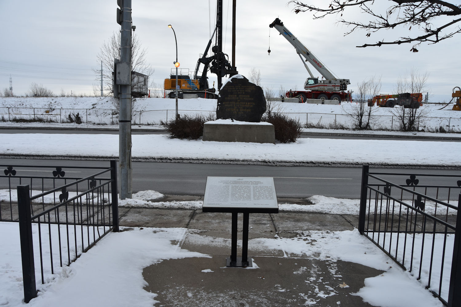
3. The Ship Fever Monument (“The Black Stone”) ;
— Commemorates the deaths of 6,000 Irish immigrants who died during the famine migration of 1847.
— The stone was erected on Dec. 1, 1859 by workers building the Victoria Bridge.
— The inscription reads ““To Preserve from Desecration the Remains of 6000 Immigrants Who died of Ship Fever A.D. 1847-48
This Stone is erected by the Workmen of Messrs. Peto, Brassey and Betts Employed in the Construction of the Victoria Bridge A.D. 1859”
4. Victoriatown (“Goose Village”) ;
— Traditionally Irish, this neighbourhood was built on land where Irish famine immigrants arrived on ships. Later Italian and Polish immigrants moved in. Named Victoriatown as it was at base of Victoria Bridge; nicknamed “Goose Village” as there was once many geese that migrated here.
— When the city of Montreal was to host their World Fair titled Expo 67 in 1967, they had this entire neighbourhood destroyed in 1964 and resettled it’s inhabitants elsewhere.
5. The Autostade ;
— The only reason the Autostade is mentioned here is that it was built on the former Victoriatown land and on burial ground of Irish immigrants. It was home turf for The Montreal Alouettes football team and a venue for rock concerts. It was demolished in late 1970’s.
6. Habitat 67 .
— Part of Expo 67 and designed by architect Moshe Safde, it was fundamental in design and structure.
We started this walk on de la Commune Street West at the corner of rue des Soeurs Grises in Old Montreal right where the Daniel McAllister tug boat is. This tug boat, built in 1907, is the largest preserved tug in Canada and the second oldest preserved oceangoing tug in the world. Nice to see.
Cross over the canal on the path to Windmill Point. You can walk back along the grain silos all the way south on Mill Street to Bridge Street (Rte. 112), turn left as if heading towards the Victoria Bridge and you will come to the Ship Fever Monument (The Black Stone). Across the street is a small monument to Victoriatown citizens killed in the Second World War as well as a monument to the workers who built the Victoria Bridge.
Turn north onto Rue des Irlandais and then onto chemin des Moulins, under the highway and onto Avenue Pierre-Dupuy. If you can make your way over and behind the Port of Montreal building on your right, you will get a good vantage point to take a picture of the Victoria Bridge. Continue along Avenue Pierre-Dupuy to Habitat 67. You will get a good view of Montreal and the Old Port.
Note of caution: this area includes industrial activity, can include fast traffic on some streets and heavy machinery at times. Always look every way when crossing streets or taking photo’s.
Hydrography map of Montreal Harbour showing Windmill Point, “Emigrant Sheds” and the Victoria Bridge (Admiralty Map, Royal Navy 1858/1860)

Map of Montreal showing Windmill Point and The Irish Monument, which was closer to the Victoria Bridge (Bishop’s New Map 1867)

Map of Montreal showing Windmill Point and The Irish Monument, which was closer to the Victoria Bridge and the green circle shows where Victoriatown stood (Johnstons Complete Map 1872)

Windmill Point

Beginning of the Lachine Canal at Montreal Harbour
opened in 1825 for use

Daniel McAllister tugboat
built in 1907


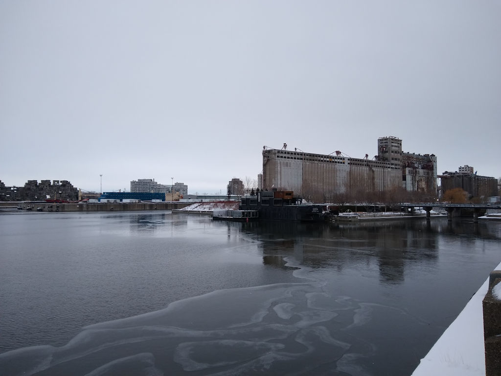
Abandoned Silo No.5 on Windmill Point
built in 1903 by The Grand Trunk Railway, these silo’s made Montreal the largest grain handling harbour in the world in the 1920’s.


Sketch of the windmill at Windmill Point on the cover of Canadian Illustrated News (July 19, 1879)
The windmill also served as a morgue.

On Windmill Point – looking back at the harbour and Old Montreal.
The Windmill would be right at this location

Mill Street- looking west

old Fire Station 21 on Mill Street – built 1912

Five Roses flour building – built 1946

Canada Maltage

Irish Monument Stone, originally in Etienne Cemetery – Bain News Service.

Current location of the Irish Monument Stone – in the middle of a busy road (Bridge Street a.k.a. Rte 112)
Bad choice where to place it, as people cannot get close without putting themselves at risk.

Irish Monument Stone.


Inauguration of stone on December 1, 1859
Montreal Gazette

Article from The Freeman’s Journal (Dublin)
Friday December 30, 1859

Article from The Belfast News Letter (Belfast)
Tuesday January 3, 1860

Irish Monument Stone description.


Victoriatown Memorial.
This memorial stone is the only reference to Victoriatown that we found.


Victoria Bridge Memorial.


Beginning of the Victoria Bridge

Victoria Bridge


Victoria Bridge (1860) – courtesy of The Library of Congress.

The following images are of Victoriatown, photographed in 1963, courtesy of and credit to Archives Montreal.
These are the streets of Forfar, Menai, Conway and Britannia.
You can see in most of the photo’s an archive document card with numbers/letters to archive the photo for reference purposes. The city of Montreal had already passed law to have this neighbourhood destroyed the following year in 1964.
You can see these images and many more at Archives Montreal here:


Habitat 67


Autostade
Credit to Archives Montreal

There is a painting titled “Le Typhus” (circa 1849) by Theophile Hamel.
It was commissioned by Bishop Bourget to commemorate the epidemic

“Le Typhus” can be found in The Notre-Dame-de-Bon-Secours Chapel (400 St Paul Street East in Old Montreal)
As soon as you enter the front doors, it is directly above you on the ceiling under the choir loft.

Back to Top
website and images © www.walkmontreal.com
The pictures bring back such fond memories of my childhood. Thank you.
Thats great Richard. Glad you enjoyed the photos.
My earliest memories are of the people of the village. Everyone knew everyone. Surnames of family Griffin,Hebert,Shanahan,Martin,Stevens. My cousins still live in Montreal. I still enjoy looking at pictures from that time. Only wish my Mother had put names on them. Thank you for the photos.
Thank you Norma. Glad you enjoyed the pictures.
I’m a Hebert (Ian) … my mother is Mary, and we lived on Forfar Street. My granny Shanahan and my Uncle Eddie lived a few doors down.
My father’s sister (my aunt Marguerite Hebert) lived a few doors down, and a couple of streets over my uncle Jim Shanahan (and my cousins Tommy and Theresa) lived.
Hello, My name is Marisa Portolese, I am an artist and professor at Concordia University. I am working on an extensive project about the Goose Village. If you or someone you know once lived in the Goose Village, please do get in contact with me. I would love to hear about your experience and include your voice in this project. I can be reached at m.portolese@videotron.ca
Hello Marisa, thanks for visiting WalkMontreal. We have not lived in Goose Village, but, will add your request here on the website if anyone has lived there, they can contact you direct.
Hello Marisa, There is a person who is searching for a picture of Victoria Presbyterian Church
( closed 1940) that was located at 52 Conway St, in area called Victoria town, that was torn down by city in 1964 before Expo 67. Could you help where to search? Thanks. Richard Lancing riclanc@total.net
Many of the black and white photographs of GooseVillage have been painted by me, in my unique style, and colours.If you want a better feeling of what was “destroyed” by progress in the 1960’s, just Google Michael Litvack Artist, to get to the Fine Art America site…then click on COLLECTION to find the Goosevillage paintings, merged with Point ST Charles, and St. Henri.
Is it possible to obtain a picture of the Victoria Presbyterian Church ( closed 1940) that was located at 52 Conway St, in area called Victoria town, that was torn down by city in 1964 before Expo 67.
Hello Richard, Yes it is possible. Please contact me at m.portolese@videotron.ca, thank you, Marisa
I was wondering if anyone knew of a tavern called J.P. Murray which would have been open in the early 1900s. It was located in Goose Village as my Great Grandmother worked there for/with (not sure of this detail) her father John Welsh. I have two very faded photos of this and of another ancestor who worked in a general store in Goose Village as well. Not sure where the location would have been.